Riverside sits atop alluvial fans and ancient river terraces from the Santa Ana River, with groundwater tables fluctuating between 10 and 25 feet depending on the season and proximity to the channel. The region also lies within California's seismically active zone, meaning slope failures here are not just a rainfall issue but a ground-motion trigger as well. Our monthly geotechnical slope monitoring program in Riverside tracks surface and subsurface displacement using inclinometers and piezometers, feeding data directly into limit-equilibrium models. Before deploying permanent instrumentation, we often run a MASW-Vs30 survey to characterize the shear-wave velocity profile, which is critical for estimating site response under seismic loading. The data we collect each cycle helps distinguish progressive creep from sudden deformation, giving owners time to intervene before a slide accelerates.
Monthly monitoring catches seasonal shifts in pore pressure before they trigger a slide, giving owners 30 to 60 days of warning time.
Method and coverage
Riverside averages only 11 inches of rain per year, yet when the winter storms do hit, the dry, fractured granitic soils on the Box Springs Mountains and surrounding hillsides can lose apparent cohesion rapidly. That contrast between extended dry periods and sudden saturation makes monthly monitoring essential — weekly checks would catch little change most of the year, but a monthly interval catches the seasonal shift before the next heavy rain. We install vibrating-wire piezometers to track pore pressure buildup and combine those readings with manual survey prisms on key tension cracks. For deeper movements, we rely on in-place inclinometers that report tilt every 0.5 meters along the casing. Complementing these measurements with a resistivity survey helps map moisture pathways that aren't visible at the surface. The result is a dataset that separates normal thermal expansion from real slope creep, allowing us to calibrate the factor of safety on a monthly basis.
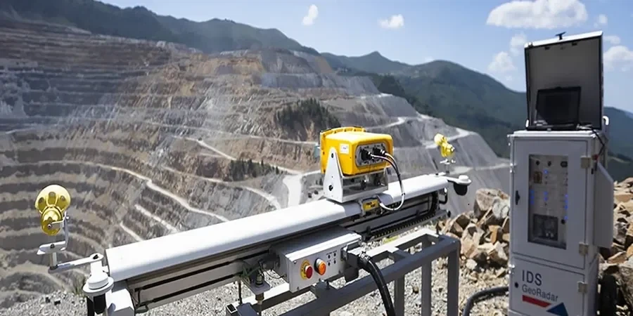
Technical reference image — Riverside
Regional considerations
A common mistake we see in Riverside is contractors relying on a single dry-season baseline and assuming the slope is stable year-round. That approach ignores the effect of winter infiltration into the weathered granodiorite and the perched water tables that form after only two or three significant storms. Without monthly monitoring, a slope that showed a factor of safety of 1.5 in October can drop to 1.1 by February — and that narrow margin is where a 4.5 magnitude aftershock or a burst irrigation line can push it over the edge. We have documented cases where a 30-day gap in readings missed the onset of a 12 mm displacement that led to a full debris flow within three weeks. Monthly cycles are not a luxury here; they are the minimum interval to catch the transition from stable to metastable conditions.
Permanent in-place inclinometer casings installed to depths of 25 m, read monthly with a portable probe or automated datalogger. Data is reduced to displacement profiles and plotted against time to identify shear zones.
02
Piezometer Networks
Vibrating-wire piezometers placed at strategic depths to monitor phreatic surface fluctuations. Readings are correlated with rainfall records from the Riverside Municipal Airport station to predict critical pore pressure thresholds.
03
Surface Survey Prisms
Total station survey of reflective prisms installed on tension cracks and slope benches. Horizontal and vertical movements are tracked to ±2 mm accuracy and compared against inclinometer data for a complete kinematic picture.
How much does monthly slope monitoring cost in Riverside?
For a typical residential or commercial slope in Riverside, monthly monitoring ranges between US$440 and US$1,200 per cycle. This covers field readings, data reduction, and a monthly report. Larger sites with multiple inclinometers or remote access requirements may fall at the upper end of that range.
What is the minimum slope height that should be monitored monthly?
We recommend monthly monitoring for any cut or fill slope exceeding 6 meters in height, especially in Riverside's alluvial or weathered bedrock terrain. Slopes below 6 m with no history of movement may only require quarterly checks, but seasonal transitions still warrant a baseline cycle.
Can you combine monthly monitoring with real-time alarms?
Yes. While our standard monthly service involves manual readings, we can install automated dataloggers that transmit pore pressure and tilt data daily. If a threshold is exceeded, the system sends an SMS or email alert within minutes. This add-on is especially valuable for slopes adjacent to occupied structures or roadways.